
Historical sights in Hennessey
| Bullfoot Park Bullfoot Park is located inside the Hennessey town limits on Highway 81, just west of the site of Bullfoot Station, a watering station known for its well and the indentation in the ground resembling the imprint of a large bull’s foot. The park has many amenities for travelers. Anglers are seen regularly on the shores of the pond. There is playground equipment for the youngsters and picnic tables for a leisurely lunch. And care has been taken to meet the needs of mobility impaired travelers. The newly built public restrooms and the walking path are handicapped accessible. The walking path provides an opportunity for travelers to experience the environment of the Chisholm Trail on a concrete surfaced walkway just over one half mile in length and all 2,750 feet accessible to the mobility impaired. Early mornings on the path are characterized by the plaintive call of the Mourning Dove and the appearance of an occasional coyote, slipping in to drink from the lake—sights and sounds familiar to drovers along the Trail. | The Ima Wilson HouseChisholm Trail Marker #1 GPS Coordinates: 36° 6′ 8.21″ N 97° 53′ 58.64″ W It is appropriate that the first marker for the Trail in the town limits is placed at 722 S. Main, the home of Ima Wilson, Hennessey’s Centennial Centegenarian. There have been many changes along the trail in the century that has passed since its closing in 1884. As of 2008, Ima witnessed 104 of them before her death. When Bob Klemme was setting markers along the trail, he asked Ima for permission to place a marker in her yard. She was very resistant, but after a few years determined that the marker would be just fine. She insisted that Bob come in for a visit when in the area and, today, Bob Klemme has his Ima Wilson stories. The house itself is now gone, but Ima’s spirit is still strong on that historic corner. |
| Chisholm Trail | Baker’s ranch 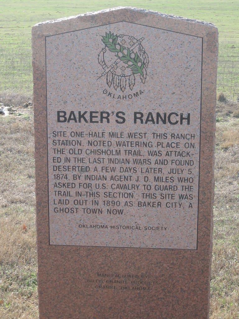 The Route—from the north Of all the towns that have sprung up along the Trail, Hennessey is unique in that, here, Highway 81 was built on the Trail, not parallel to it. The route of the Byway through Hennessey is very simple to traverse—it is Highway 81. Located 2 miles south of Hennessey on the west side of Highway 81, this marker gives the location of Baker’s Ranch, a watering place on the Trail that gained notoriety from the outlaws that visited there. The ranch, set up by J. W. Baker in 1872, was a trading station serving the drovers on the cattle trail, and it later became a stage stop along Turkey Creek. It was also the rest stop of choice for a gang of horse thieves that hid in the blackjacks on the creek and stole Indian ponies, creating much difficulty for John Miles, the Cheyenne-Arapaho agent and a contributing factor in the Buffalo War. The ranch buildings are gone, but the blackjacks still grow thick on Turkey Creek and give a glimpse of the terrain in the closing days of the trail |
Pat Hennessy | The Land Run  |
| the hitching post main and Iowa st |
| first post office |
| ranch room |


| Memorial park | Pat Hennessy Park | Boy Scout Park |